
Rotterdam’s coastal location has been a key factor in its development, but at the same time it has made the city vulnerable to natural disasters. The city has repeatedly faced crises that could have become fatal for it. However, each time Rotterdam managed to choose the path of revival and adaptation. Today, it is difficult to find another city implementing such multifaceted measures and innovations in water resource management.
In this article, we will trace the history of Rotterdam through the lens of its fight against floods, and also analyze nationwide governance decisions and innovative technological approaches that promote the city’s harmonious coexistence with the environment.
From a fishing village to a trading port: How traditional dikes, polders, and the fight against floods influenced the development of Rotterdam
The development of Rotterdam has always depended on the ability to control the elements and protect itself against floods. Some principles laid down as far back as the Middle Ages still remain relevant today, although they are now only part of a more complex and extensive protection system. So how did it all begin? With traditional dikes. These typically referred to earthen embankments reinforced with wooden structures and sometimes stone facings. They were built to protect settlements, agricultural lands, and roads from floods and sea tides.
 1705, Anonymous, 1705. Image: dutchdikes.net")
In the case of Rotterdam, such a dike was built around the year 1270 on the Rotte River, blocking a peat stream, and this was the development that marked the beginning of the future city. At first, Rotterdam was an unremarkable fishing village, overshadowed by more influential cities in the region. Today, almost nothing reminds us of this earliest period in the city’s history, except for the landscape, where one can still see the medieval water structure and the strip of dikes that protected the residents from floods.
Starting from the 13th century, the inhabitants of the Netherlands began building small dikes to keep certain areas dry for as long as possible. Over time, these isolated efforts evolved into a systematic and larger-scale land reclamation process. The foundation of this process was the construction of large dikes and the drainage of land, resulting in the creation of so-called “polders,” low-lying areas, often situated below sea level, protected from flooding by dikes.
In order for polders to remain suitable for living and agriculture, it is necessary to continuously pump out groundwater that accumulates as a result of precipitation and seepage.

This problem is difficult to deal with alone, so associations and an established system of cooperation are needed to achieve collective safety. After all, dikes require constant maintenance, and polders need control over their dryness. That is why specialized structures emerged, “polder councils” or “water councils,” which coordinated these efforts and ensured effective water resource management.
Port development
The period from the 16th to the 18th century is known as the Golden Age of the Netherlands, and it was during this time that Rotterdam became an important trade center, the second-ranking merchant city of the Republic. The expansion of the port city gave Rotterdam its characteristic triangular shape.

The Golden Age came to an end around 1730, when the region faced a serious threat, namely the appearance of the naval shipworm (Teredo navalis). The warm and humid climate contributed to the rapid spread of this mollusk, capable of penetrating submerged wood — including poles, ships, and breakwaters — and boring numerous tunnels inside. Such wood could appear undamaged on the outside, but inside it became brittle and vulnerable. As a result, structures often collapsed suddenly, since the damage was only discovered at late stages. Wooden constructions along the coast, particularly dike breakwaters, began to collapse en masse. In response to this new threat, active efforts were launched to find more reliable materials and engineering solutions for dike construction. Despite its destructive consequences, this disaster became a catalyst for dike modernization.
Until the mid-20th century, there was no clear understanding of what exactly influenced the strength of dikes or what mechanisms led to their failure. Their construction, height, and slope were determined solely based on historical practice. Typically, the height of a dike was chosen by referring to the highest recorded flood level, adding about half a meter as a buffer in case of unforeseen circumstances.
In 1940, Germany launched its invasion of the Netherlands, and Rotterdam, as a strategic port city, became one of the main targets. As a result of a massive air raid, the city center was almost completely destroyed.

Shortly after the upheavals of World War II, the Netherlands faced a new, no less devastating disaster — the catastrophic flood of 1953. On the night of January 31, 1953, the Netherlands experienced one of the most horrible floods in its history, which claimed the lives of over 1,800 people. A high spring tide combined with powerful gusts of wind created a perfect storm. The tragedy was worsened by the fact that the disaster struck at night, on a Saturday, when local radio stations were off the air — meaning there was no warning. People had no idea that danger was approaching.

In the end, the dikes were breached in more than five hundred locations across the country. In Rotterdam and its surroundings alone, over 72,000 people were left homeless in a single night. The dikes, weakened by the war and partially damaged by Allied bombings, remained vulnerable. Despite some repair efforts, the water management system was fragmented: responsibility was divided among numerous institutions, many of which had limited funding. Excessive bureaucracy further complicated rapid response to threats.

Whereas in the past flood protection was primarily managed at the local level — particularly through the aforementioned polder councils — after the 1953 flood, these issues began to be addressed at the national level. Just twenty days after the tragedy, the Delta Commission was established to coordinate flood protection measures. The Commission developed a large-scale engineering program aimed not only at protecting the country and cities from major floods but also at addressing local challenges such as heavy rainfall and its impact on the urban environment.
Local and national urban planning solutions in the fight against potential city flooding
Climate change is becoming increasingly apparent: the average annual temperature is rising, and ice at the North and South Poles is melting much faster than it did 20–30 years ago. These changes are already affecting Ukraine, where the frequency and intensity of extreme weather events such as heavy rains and floods are increasing. According to research, the number of intense rains in Ukraine has grown, particularly in Crimea, Zakarpattia, and the Ivano-Frankivsk and Chernivtsi Regions. It is projected that by 2100, nearly 650,000 hectares of land may be flooded, and when rising sea levels are taken into account, this figure could reach up to 1 million hectares. The most affected regions will be Crimea as well as the Kherson and Odesa Regions.
In the Netherlands, 26% of the territory lies below sea level. If low-lying areas were to be flooded, one can see on the map how cities such as Amsterdam and Rotterdam would end up underwater. In total, 59% of the Netherlands could be flooded, which would have serious environmental and humanitarian consequences for the country.

Since most of the Netherlands is at risk of flooding, the government has adopted centralized urban planning and nationwide solutions aimed at improving the situation and preventing flooding. One of the largest-scale national projects is the implementation of the Delta Plan. It began with the construction of the barrier on the Hollandse IJssel. This barrier, located east of Rotterdam, was completed in 1958 and plays a crucial role in flood protection for the lowest part of the Netherlands—6.5 meters below NAP (Normaal Amsterdams Peil or Amsterdam Ordnance Datum, the vertical reference standard currently used in Western Europe to measure water levels from Amsterdam’s base level).
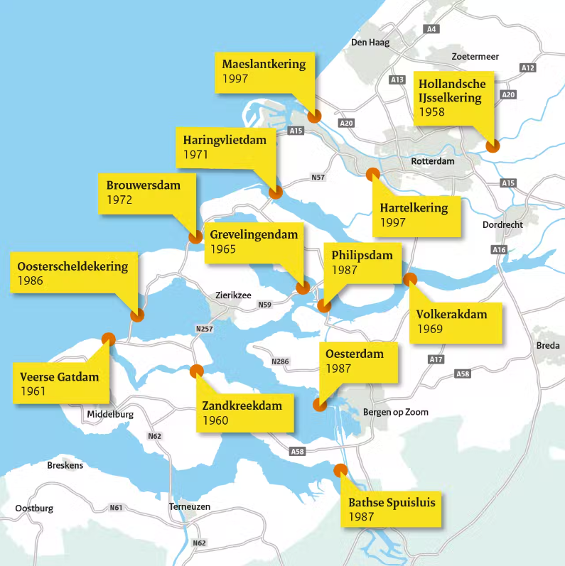
The image above shows the location and year of completion of the dikes. Thanks to these hydraulic structures, the Dutch were able not only to protect their territories from water but also to create an extensive transportation network. The dikes also serve as bridges, connecting separate “islands” with one another.
During the construction of the dikes, some areas were flooded, resulting in the formation of artificial saltwater lakes. Such interventions in natural systems disrupted existing ecosystems and gradually led to the formation of new ones. Today, the lakes are used as recreational areas.
")
Let us take a closer look at the urban planning solutions adopted at the local level in Rotterdam. The image above presents water management measures in Rotterdam, which illustrate a comprehensive flood protection system. The city is equipped with an extensive infrastructure that includes dikes, sluices, pumping stations, and storm surge barriers. The potential threat of storm waves from the North Sea has been reduced thanks to several important construction projects, such as the Europoortkering, which includes the Maeslantkering storm surge barrier project and the Hartelkering reinforcement of dikes in the lower part of the river. Today, the operation of pumping stations is centralized, and drainage in the low-lying parts of the city is monitored around the clock.

Rotterdam also has a system of canals that historically developed as part of the city’s efforts to manage water. The canals function as both natural and artificial drainage channels that direct excess water into the Maas and Nieuwe Maas rivers. Water that accumulates in urban areas due to rainfall or rising sea levels is directed into the canals and then pumped into the rivers or the sea using pumping stations. Numerous sluices are installed in the canals to regulate the flow of water depending on the levels in the rivers and the sea. This allows for flood control and water retention during dry periods.
The sponge city concept
The sponge city concept has gained wide discussion and application in the Netherlands. It is a modern approach to managing rainwater.
Unlike the traditional method of managing rainwater, which involves quickly diverting it out of the city using “gray infrastructure” (concrete, pipes, pumps), sponge cities aim to retain as much water as possible within the urban area (De Urbanisten, 2021). This is achieved through the use of natural and green infrastructure, which allows water to infiltrate, accumulate, and gradually return to the ecosystem, thereby reducing the load on traditional drainage systems.

The main idea is to slow down the flow of water and allow it to be absorbed by the soil instead of quickly diverting it. To achieve this, solutions such as rain gardens, loosened soil, permeable paving, green roofs, urban wetlands, and similar measures are used.
Sponge city technologies are designed to integrate into the natural urban environment to such an extent that they are often unnoticeable. In some cases, “normal people, i.e. not urban hydrology experts, don’t necessarily realise that it’s a Sponge City district. The interventions are always created in a multi-functional way.” [14]

For example, Rotterdam has already implemented one of the sponge city concepts, the so-called “sponge garden.” This project, which is more of an experiment, was developed by the company De Urbanisten. The garden space is divided into three zones, each exploring different aspects of interaction with water and the landscape’s absorbent capacity.

Soil Cubicles
This zone helps understand how to improve the water absorption capacity of urban soils. Four typical soil types common in Rotterdam were selected. Each area is divided into several sections: a control section (with soil in its natural state) and three sections with modifications—with the addition of organic, inorganic, and innovative materials. All sub-sections are hydrologically isolated, allowing for highly accurate measurement of the amount of water absorbed.
Waving Wadi
This part of the study focuses on the capillary infiltration of water between areas with different elevation levels. The goal is to ensure the rapid collection and transport of rainwater during heavy precipitation, as well as its retention. The Wadi functions as a natural drainage system that retains water and gradually moves it away, preventing flooding.
Depave Garden
The goal of this section is to find a simple and affordable way to increase green space in the city. The focus is on solutions that are low-cost, easy to install, and easy to maintain. This approach can be either temporary or long-term, with the possibility of being easily integrated into the urban environment without complex replanning.
Water reservoirs: parking garage, multifunctional spaces
In Rotterdam, architects and engineers are developing the concept of multifunctional urban spaces that adapt to different weather conditions. In everyday life, these spaces serve as playgrounds, parking lots, or parks, but during floods or heavy rains, they transform into reservoirs for collecting rainwater.
One such solution has been the creation of floodable squares, lowered areas of urban space that temporarily retain water during rainfall or floods (especially when located near a river or the sea). When the water level rises, these squares become partially or fully flooded. On ordinary days, they remain fully functional public spaces for sports, leisure, or meetings.
The first fully realized square of this type was Benthemplein, which opened in 2013. In dry weather, it functions as an urban public space with a basketball court and recreational area. Instead of storing water underground, the water square makes the reservoir infrastructure visible to the public, thereby inviting interaction. The patterns on the surface resemble meteorological maps.
Тут має бути галерея № 1
Another example is the multifunctional inner dike Dakpark in Rotterdam, a space that combines nature, the urban environment, and water management infrastructure. At the same time, Dakpark serves as a barrier against wind and noise from the port area. It is one of the largest “green roofs” in Europe and demonstrates how ecological design can be organically integrated into the structure of a city.
The idea for this project emerged back in 1998, and the park itself was opened in 2014 as Rotterdam’s first stepped dike with several flat levels. On one side of the dike is a brick façade with storefronts, and on the other is a park, beneath which are garages, shop buildings, and a service road. The park includes several residential sections, including areas for children and their parents, and offers a panoramic view of the city.
Тут має бути галерея № 2
Another innovative urban project that helps address the problem of land scarcity and flood risk amid rising sea levels is floating neighborhoods. They are part of the city’s sustainable development strategy and demonstrate how modern architecture can adapt to climate change. The houses in these neighborhoods are located on water and are capable of adapting to rising water levels.

***
We observe a key pattern — the potential for resilience consists of three components: to anticipate, to avoid, and to adapt/recover. Rotterdam has become a vivid example of how this resilience can be achieved. The city has managed to create conditions under which it not only continues to develop but is also prepared for adverse events such as heavy rainfall or rising sea levels.
Projects like the DELTA dikes, floating city technologies, the network of canals and pumping stations, as well as centralized water management centers, have enabled the Netherlands to transform areas lying below sea level into safe places to live. Moreover, thanks to innovation, people can not only live near water but also use it for energy production. The Dutch government has created a new water pumping system that allows for maintaining a balance between nature and urban needs.
Although Ukraine’s territory does not lie below sea level, due to climate change and rising global ocean levels, the levels of the Azov and Black Seas are also expected to rise. This could lead to the flooding of coastal areas in the Odesa and Kherson Regions as well as parts of Crimea. In view of these threats, we already have the opportunity today to develop a resilience plan, anticipate possible scenarios, and find ways to deal with extreme weather. The experience of Rotterdam can confidently be taken as an example for developing similar urban planning solutions that would help Ukraine adapt to climate change, particularly in coastal regions. Attention should also be paid to Zakarpattia, which is already suffering from flooding due to heavy rainfall. Thus, the issue of water resource management is relevant not only in the South of Ukraine but also in other regions of the country.
Sources
- The history of the founding and urban development of Rotterdam.
- Flood forecasts for the city of Rotterdam.
- The tragedy of 1953.
- Rotterdam urbanism. The water city of Rotterdam 2100.
- The pumping system in Rotterdam.
- The Deltawerken system. The situation of Rotterdam and the Netherlands with rising sea levels.
- Dikes, the Deltawerken system.
- Construction of the Deltawerken.
- Local urban planning solutions of Rotterdam/
- The City Water. Resilience Approach. City Characterization Report, Rotterdam.
- The sponge city of Rotterdam.
- Sponge garden in Rotterdam.
- Climate change in Ukraine.
- Urbanism 101: What is a Sponge City?
This study is the result of the educational seminar Learning from urban resilienсe international — transfer points for Ukraine within the framework of the project DAAD Ukraine digital: securing academic success in times of crisis, supported by the Federal Ministry of Education and Research (BMBF). The seminar was held in cooperation between the Rheinland-Pfalz Technical University of Kaiserslautern-Landau (RPTU) and the Kyiv National University of Construction and Architecture (KNUCA), with the participation of architecture, urban planning, and geography students from KNUCA, Kyiv National University, O.M. Beketov Kharkiv National University of Urban Economy, and Odesa State Academy of Civil Engineering and Architecture.
The course is curated by Liubov Apostolova-Sossa, PhD in Technical Sciences, Head of the Department of Urban Economy at the Faculty of Urban Studies and Spatial Planning of the Kyiv National University of Construction and Architecture; and Anna Kuzyshyn, urban planner and architect, researcher at the Department of Urban Planning at the Rheinland-Pfalz Technical University of Kaiserslautern-Landau (RPTU).
Cover image: Daniel Stiel / Unsplash